
 @wxornotBG Facebook
 @wxornotBG Twitter
 @wxornotBG Instagram


Will & Carlton are excited about the upcoming increase in temperatures. Aren’t we all?
This Afternoon – Sunny & COLD – High 17˚ / Tonight – Clear – Low 14˚
3pm 17˚ ~ 6pm 15˚ ~ 9pm 16˚ ~ 12am 16˚ ~ 3am 14˚ ~ 6am 15˚
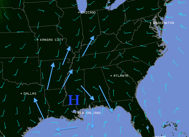
High pressure continues to build north into south central Kentucky, which has provided partly to mostly sunny skies across the region today. Expect this trend to continue into this evening, as the cold temperatures hang around.
The good news is that winds have shifted from out of the southwest. This will bring warmer air into the region starting tomorrow. We can thank the high pressure’s clockwise rotation for this shift. Tonight, will be clear and cold. Take a look at the following model for a look at 3pm surface conditions:
Wed – Partly Sunny – High 39˚ / Wed Night – Increasing Clouds – Low 25˚
Southerly winds between 5-10mph will pump MUCH warmer air into the region, which will result in a warm up of 10-20˚ compared to what we’ll experience this afternoon. Wednesday night, cloud coverage will take over, as moisture takes over the region ahead of our next disturbance.
Thu – Scat’d Rain & Snow Showers – High 44˚ / Thu Night – Scat’d Showers – Low 33˚
Temp profiles will be below freezing early Thursday morning, as an isolated/scattered precip begins to fall. We’ll have the potential to seeing a light, wintry mix through this time. This is supported by the GFS precip model below, valid for 6am Thursday morning:

A few scattered rain/snow showers aren’t out of the question. I’m not really concerned about any traveling impacts, as this should be a very minor event…if any frozen precip even makes it to the ground, that is. If we do see frozen precip, expect a quick transition to scattered rain by mid morning.
Scattered showers will continue to pester us through Thursday night and the start of our Friday, as an upper level trough approaches from our west.
This will result in widespread rain showers Friday night – Saturday, with rainfall values of up to 1+” not out of the question. The GFS thickness loop below is valid from 6pm Friday – 12am Sunday in 6 hour increments. It looks to be damp:

Even through it may be raining, there’s still good news! Our warming trend will continue through this time frame, with highs near 50˚ come Friday & Saturday.
That’s all I’ve got, folks. Stay in touch at @Wx_Or_Not for more frequent weather information. Have a question? Get it to me there. Enjoy your Tuesday. Thanks for reading.