
 @wxornotBG Facebook
 @wxornotBG Twitter
 @wxornotBG Instagram

Good morning, Kentucky! We’ve woken up to another brisk morning and it’s safe to say that it’s the “I need five extra minutes in the morning so I can work up the courage to get out from under the covers” time of year. We’re in for a chance of rain and snow today as well as on Friday. I’ve got all the details below!
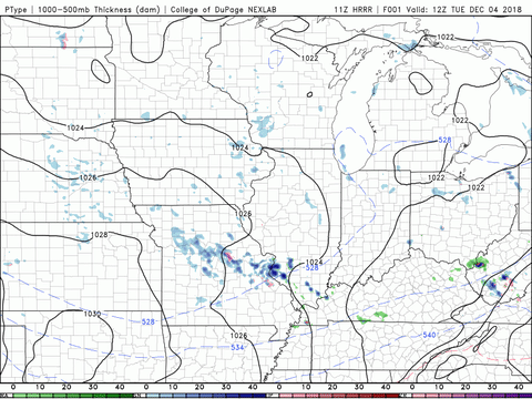
Possibility of Rain/Snow Today
Today’s high temperature won’t feel like much of a high as we will only see the upper-30s today. You might experience some snow flurries during your morning commute but that precipitation should shift to rain during the late morning and continuing into the early evening hours. As it gets dark, the sky should clear and we’ll be dry through tomorrow. Winds will be light out of the northwest and the low will drop to the low-30s.
Frigid Wednesday
Our temperatures won’t be cutting us any slack on Wednesday either as the high will only reach into the upper-30s once again. Thankfully, we will have a break from precipitation possibilities and get to enjoy a little sunshine. Winds will be light out of the west/southwest and the low will drop to the chilly mid-20s.

Rain/Snow Returns By Thursday
Temperatures will be a little nicer on Thursday with highs expected to reach into the low-40s. Precipitation chances will return after lunch time and will increase in likelihood as we move into the early evening hours. The rain may switch to a rain/snow mix during the overnight hours but we should be clear by Friday morning. The low will drop to the mid-20s, so bundle up!

That does it for me! I hope everyone has a great day and stays warm. Make sure to follow @wxornotBG on Facebook and Twitter for updates on the rain and snow possibilities this week.