
 @wxornotBG Facebook
 @wxornotBG Twitter
 @wxornotBG Instagram

On Saturday night, Bowling Green and the rest of south central Kentucky was impacted by a familiar weather foe to the Ohio and Tennessee Valley’s. This familiar foe is referred to as a squall line. I snagged the following screen shot at approximately 8:20pm Saturday night. It displays the squall line as it plowed east across the region:

A squall line is defined by the National Weather Service as follows:
“A line of active thunderstorms, either continuous or with breaks, including contiguous precipitation areas resulting from the existence of the thunderstorms.”
Classic squall line events most commonly evolve ahead & parallel of an approaching cold front. This is where a warm, moist airmass (its fuel) supplements its stronghold. The leading edge of squall lines often present the greatest straight-line wind threat…a threat that came to realization for many Saturday night. Weak tornadoes can also occur along the leading edge of these weather events, just as we saw take place near Campbellsville. Hail and torrential rainfall are also common traits within a classic squall line setup.
Thunderstorms will first initiate where there is the best combination of moisture, instability and lift. The storms will continue to evolve and new cells will develop (usually to the south & east of the initial line). The squall line will eventually prolong itself by producing its own lift due to outflow boundaries. As long as instability and moisture remain present out ahead of the squall line, the squall line will continue its longevity.
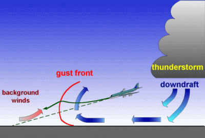
I snapped the following photo on May 29th, 2013 in western Oklahoma while storm chasing on the plains. This helps you visualize what a classic squall line may look like if you were to witness one during the day. A gust front forms along the leading edge, with very intense winds brought to the surface as the gust front passes.

I hope this helps you understand the characteristics of a squall line weather event. If you have any questions, don’t hesitate to get in touch with me @Wx_Or_Not.