
 @wxornotBG Facebook
 @wxornotBG Twitter
 @wxornotBG Instagram

Good morning, Kentucky! I hope everyone’s week got off to a great start. Prepare to remain soggy as we have more showers and storms lined up for today. Tomorrow, however, looks absolutely beautiful as we get a glimpse of Fall through lower temperatures and humidity. I’ve got all the details below!
Wet Tuesday
As we progress throughout the day, those showers that are currently out to our west should transition into scattered thunderstorms. Your commute home could be impacted by some of these scattered thunderstorms, so stay updated on the timing throughout the day.
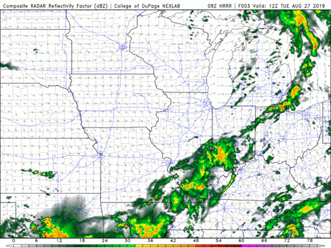
These storms will likely not clear the entire wxornotBG area until late tonight. However, the overnight hours look dry. As for heat, the rain will give us a continued break and limit our high temperature for the day to the low-80s.
Beautiful Conditions On Wednesday
A break from a few days of rain will arrive on Wednesday. The cold front passing through our area tonight will leave behind cooler and drier air, which will hold our high temperature back in the low-80s.
With no rain expected during the day, tomorrow should feel pretty great. Conditions will not feel as muggy due to a drop in the dew point temperature as well.
Glimpse of Fall on Thursday
Thursday will be similar to Wednesday with no rain, highs in the upper-70s, and a much needed break from the humidity. A break in the mugginess and these lower daily high temperatures are giving us a great glimpse of Fall. If you’re like me, you can’t wait to breathe the crisp air and hear the leaves crunch under your feet!
End of the Week/Weekend Outlook
As the wind shifts back toward the southwest our conditions will return to slightly warmer and more humid. Friday and Saturday will bring highs in the low-80s with Sunday looking just a few degrees warmer. Everything looks dry for the foreseeable future, so any outdoor weekend activities should be good to go.
That concludes today’s post! Remember to follow @wxornotBG to stay updated on today’s storms. Have a great week!