
 @wxornotBG Facebook
 @wxornotBG Twitter
 @wxornotBG Instagram

Good morning, Kentucky! We’re headed into another sultry day as we gear up for thunderstorms later this afternoon. With thunderstorms likely the rest of the week, have your rain gear ready and stay weather aware. I’ve got all the details below!
Afternoon Thunderstorms Today
Today will reach the scorching mid-90s and with dew points in the low-70s, it will feel like it is in the low-100s. Be extra careful in this extreme heat because it can be dangerous. Refresh your memory with these heat safety tips from the National Oceanic and Atmospheric Administration (NOAA):
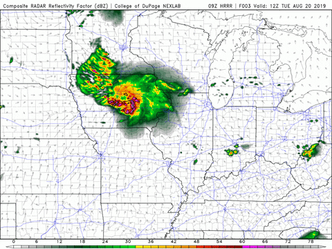
Thunderstorm chances will not come into the picture until later this afternoon. These thunderstorms should start out scattered and transform into a more widespread system as we get closer to the evening. As of right now, the Storm Predication Center (SPC) has Bowling Green just inside a Slight Risk (2/5) area for severe weather.
Tonight’s Storms Continue Into Tomorrow
There is potential for today’s storms to continue through the night and throughout much of tomorrow. The severe threat, however, should be over by then.

Temperatures will reach the low-90s with dew points in the low-70s again, so prepare for another extremely muggy day. Conditions will feel the worst during any breaks from the rain.
More Thunderstorms On Thursday
The unsettled pattern will continue into Thursday as the early morning starts off dry but quickly transitions into possible thunderstorms by late morning.
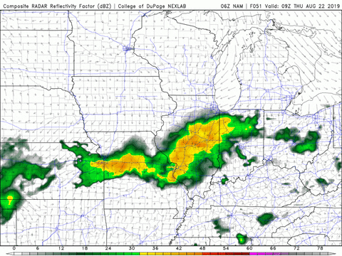
A cold front will pass through our area on Thursday morning and leave behind slightly cooler conditions. The high temperature should only reach into the mid-80s, however it will still be muggy with dew points in the 70s.
End of the Week/Weekend Outlook
The cold front that will pass through on Thursday will have a greater impact on Friday’s temperatures causing us to reach only into the low-80s. Temperatures will remain similar to this throughout the weekend with slightly lower dew points as well. Although these conditions would be great for any outdoor plans, the chance of thunderstorms will continue throughout the weekend.
That concludes today’s post! Have a great Tuesday and remember to follow @wxornotBG on Twitter to stay updated on this week’s storms. See you next time!